
A cave outside a small town in the highlands of Chumbivilcas is one a 19th-century explorer once climbed into, stooped low beneath a ceiling of thick stalactites, and wrote about in a report almost nobody outside Peru ever read. That was 1868. Since then, cavers from Poland, from Spain, from Lima, have made the same trip, drawn by the same 300 meters of fossil passage carved into limestone. Almost no traveler ever has. This is Huarari Caves, also known as the Grutas de Warari, and it may be the closest thing Cusco has left to genuinely unexplored ground.
Quick facts of Huarari Caves
| Detail | Info |
|---|---|
| Location: | Livitaca district, Chumbivilcas province, Cusco region. |
| Altitude: | 3,900 – 3,910 m |
| Mapped length: | 300 m of fossil galleries, plus a separate 60 m active underground river system. |
| First documented: | 1868, by naturalist Antonio Raimondi. |
| Access level: | Remote — no established tourist circuit; route currently in development |
| Best season: | May to September (dry season) |
| Best for: | Travelers who want a genuine, low-impact wild-caving experience, not a polished attraction |
150 Years of History, Almost No Visitors
In 1865, Italian naturalist Antonio Raimondi traveled through Chumbivilcas, cataloguing the region’s natural features. When he reached Livitaca, he found what he described as a remarkable and spacious limestone cave a short walk from town, with an entrance low enough that visitors had to bend forward to pass beneath the thick stalactites hanging just inside. He wrote it into the historical record in 1868, the first known documentation of Huarari caves, and still one of the only detailed descriptions of it that exists.
More than sixty years later, in 1932, researcher César GarcÃa Rosell visited and documented the cave again. Then, decades of near-silence — until 1972, when a Polish caving expedition from the Wysokogorski club in Warsaw arrived to survey and map the passage in full, producing the first technical topography of Huarari caves. A Spanish team, the Espeleo Club Salem of Tarragona, returned to the site in 1978. And in June 2014, a team of Peruvian cavers from Lima’s Espeleo Club Andino made the trip once more, this time to collect speleothem samples, the mineral formations that build up drop by drop over centuries, each layer a record of ancient rainfall and temperature. What Raimondi found by accident in the 1860s, scientists are still studying as a climate archive today.
What’s Actually Down There
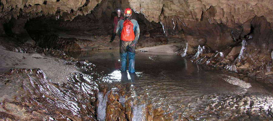
Huarari Caves isn’t one simple corridor; it’s two connected but distinct systems. The main cave is a network of fossil galleries, roughly 300 meters of mapped passage carved through limestone, no longer connected to flowing water. This is the walkable, explorable part of Huarari caves: passages you move through on foot (crouching in a few sections, exactly as Raimondi described over 150 years ago), past stalactites and other formations built up over thousands of years.
Below and separate from the fossil galleries lies the Resurgencia de Huarari caves, a 60-meter active underground river system that surfaces near the cave entrance. This part is genuinely technical: the passage ends at a sump, a point where the tunnel is filled with water, the kind of feature that only trained cave divers attempt. It’s not part of a standard visit, but it’s part of why Huarari matters scientifically: it’s a live hydrological system, not just a fossil remnant.

The Spelunking Experience at Huarari Caves
This is wild caving in the true sense of the term, not a paved walkway with handrails, but a real, undeveloped cave system that rewards preparation and respect for the environment. A visit to the fossil galleries involves:
- Moving through natural rock passages on foot, including sections where you’ll need to crouch beneath low ceilings.
- Exploring by headlamp, since there’s no artificial lighting inside.
- Observing stalactites and other mineral formations up close, including the kind of speleothems that scientists have studied for paleoclimate research.
- Navigating an uneven, natural cave floor, not a maintained trail.
What it doesn’t involve, for a standard visit: the active underground river system and its sump are outside the scope of recreational spelunking and remain a site for trained speleologists, not travelers. Any guided route Crossover develops here will be built around the walkable fossil galleries, not the technical resurgencia.
A Living Site, Not Just a Historic One
Huarari caves aren’t only a subject for scientists and explorers it still hold meaning for the community around Livitaca today. Each June, the cave is the site of the Festival de Warari, when residents perform baptisms and traditional dances at the formation, treating it as a huaca, a sacred natural feature rather than simply a geological curiosity. Any responsible visit to Huarari caves means treating it the way the people of Livitaca do: with respect for a place that’s still actively part of local life, not an abandoned ruin.
Getting There
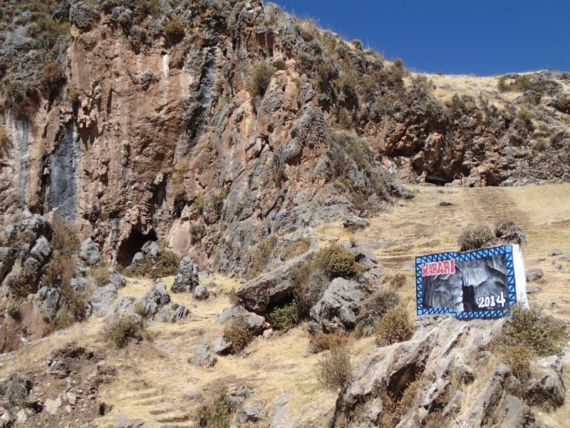
There is currently no established tourist circuit or regular guided caving service to Huarari caves. The cave sits 1.7 km southwest of Livitaca’s main square, with its entrance right at the edge of the road, physically easy to reach once you’re in Livitaca, but Chumbivilcas itself sits well outside the standard Sacred Valley / Machu Picchu route, with limited signage and roads that shift with the season. This is precisely the terrain Crossover Peru is now working to open up responsibly, with proper logistics and a small-group format.
Best Time to Visit
May through September, the dry season, offers the safest road conditions for reaching Chumbivilcas and the most stable conditions for the walk to the cave entrance. Outside these months, particularly December through March, rain affects both road access and the terrain around the cave.
Difficulty, Safety & Preparation
Huarari Caves sits at nearly 3,900 meters, in a province with limited phone coverage and roads that aren’t always passable; this isn’t a site to approach without proper planning. Inside the cave, expect natural, uneven terrain, low ceilings in places, and complete darkness beyond your headlamp. No technical climbing or rope work is required for the fossil galleries, but this is genuine wild caving, not a paved tourist path, and it calls for basic fitness, comfort in enclosed spaces, and, given the altitude and remoteness, a guided approach rather than a solo attempt.

What to Bring
- A helmet with an attached headlamp, or a reliable handheld headlamp as backup
- Sturdy, closed footwear with good grip
- Clothing you don’t mind getting dusty or damp
- Warm layers for the high-altitude approach
- Water and light snacks
- Rain protection outside the May–September window
Who Is This For?
You’ll enjoy this if:
- You’re drawn to genuinely undeveloped, off-the-map places rather than polished attractions.
- You’re curious about caves, geology, or the science of paleoclimate research.
- You’re comfortable with tight spaces, natural terrain, and high altitude.
- You want to be among the first travelers to explore a site with over 150 years of scientific history behind it.
This might not be for you if:
- You’re not comfortable in enclosed, low-light spaces.
- You’re looking for a short, fully accessible sightseeing stop.
- You’d prefer infrastructure and signage over genuinely remote terrain.